Description of walking the TMBs northern half – Tour du Mont Blanc
O
Best Format for walking the TMBs northern half
This description of walking the TMBs northern half comprises a trip through three countries in six days of walking. This makes it by far the more interesting of the two possible TMB mini-tours. There is simply no better way to walk it properly [i.e., anti-clockwise] than to commence in Courmayeur.
And what a welcome contrast it is to Chamonix, the commercial and glitzy ‘cradle of alpinism’. Its august Italian counterpart is nestled in the Val Veni on the other side of the Mont Blanc Massif. Courmayeur welcomes the hiking fraternity in a much more under-stated manner.
Reason enough to start the full TMB tour here, although you also avoid the crowds of closed groups by NOT starting in the Chamonix Valley, France. So enjoy a more relaxed introduction to walking the TMBs northern half itself: time to break yourself in gently and get up to speed, rather than hit the ground running with jet lag.
Supreme Start
Courmayeur to Arnuva is a superb first day’s hiking. Juxtaposed with ‘Lac Blanc’ as the perfect ending, we believe our mini-tour is a hiking sandwich made in heaven.
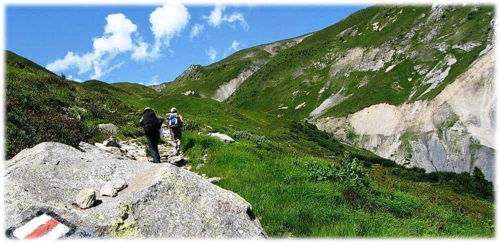
We leave Courmayeur via the Mountain Guides’ Association building. Once off the tarmac, it is a 90-minute climb until you get to the Bertone Refuge. Pace yourself as it is punctuated by fine views back down valley to Courmayeur.
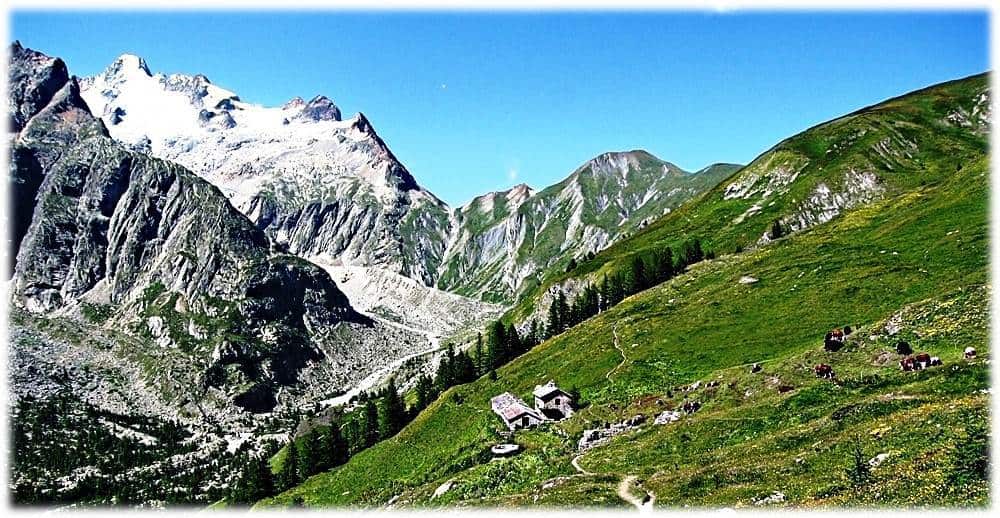
Bertone Refuge
This is your first opportunity to enjoy a short break and the first spectacular belvedere of the day. Your sense of expectation is immediately whetted. You can almost stretch out and touch the conical Mont de la Dome from the orientation table just above.
Don’t go Nuts
From this point on Day One of walking the TMBs northern half, we opt for the moderate option, ignoring the ‘are you nuts!’ variant via Col Sapin. Enjoy a gently-undulating alpine ridge that hugs the contours of Mont de la Saxe. The views off left/west along the Ferret valley and across to the peaked massif are truly invigorating.
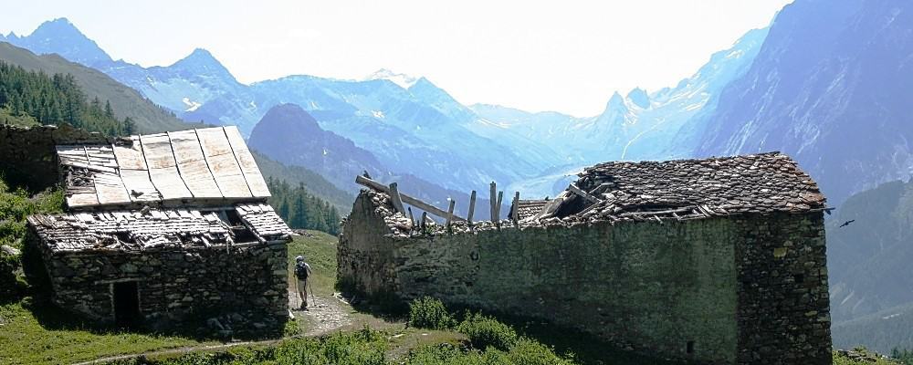
Abandoned Farmsteads
The ridge is quite exposed at first, but tree cover is found after about 30 minutes. Your path traverses juniper, billberry and larchwoods. You may cross a few day-hikers here on their way up to Bertone from Leuchey in the valley below. The scenic and undulating subalpine trail heads north-east.
You pass the abandoned farms of Leche [1929 ms alt], Arminaz [2033 ms alt., with its ravine and bridge] and Secheron. Shortly after, you commence your ascent to the next fabulous vantage point that is home to the welcoming Bonatti Refuge. This perfect lunch spot is located on a lower terrace of the Vallon de Malatra.
Bonatti Refuge
The Grandes Jorasses [4208 ms alt.] and Aiguille de l’Eveque [3258 ms alt.] are directly opposite the Bonatti refuge. Mont Blanc is still in sight. Bertone is two-and-a-half hours behind, so it is time to enjoy a lunch break and hearty fare is in abundance.
Imbibe the splendours of this picturesque, middle-mountain stop-over. You are only an hour-and-a-half away from Arnuva, with Refuge Elena a further hour from there.
Spooky Gioe
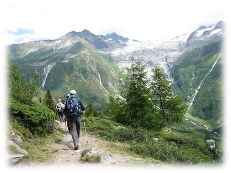
After Bertone, you negotiate a bridge over a ravine and pass through the ruins of Gioe hamlet. A protracted climb follows that is never quite gets too steep. You round a bend and level out at 2000 ms to enjoy fine views of the Pre-de-Bar glacier. Your trail traverses alpenrose and bilberry. The water in the river Ferret below is a magnificent pale green befitting of the finest aquamarine.
Rude Descent
The descent to Arnuva, bringing closure to your first day of walking the TMBs northern half, commences as a saunter through classic alpine meadow. This soon steepens after a junction with farm buildings. Thereafter, the trail steepens and is degraded until you arrive at the valley bottom. Your welcoming auberge is off left, with open-air bar for that much-needed draught lager.
Rifugio Elena
Day Two of our description of walking the TMBs northern half, takes us from Arnuva to La Fouly. It kicks off with an hour’s climb along arguably the least interesting track of the entire Tour du Mont Blanc. Without it, the refuge would be forced to re-stock by helicopter and be unable to receive hikers’ luggage. Either way, its memory is soon erased as you reach the Rifugio itself.
Elena is a slate-grey, functional-looking building overlooking Mont Dolent and the Pre-de-Bar glacier. Its rugged emplacement lacks the charm [and the fine terrace] of Bonatti, but it is comfortable inside. Like Bonatti, accommodation is a good mix of private double rooms and large dormitories. Refreshments and wholesome meals are available to all.
Grand Col de Ferret
The highlight of today’s walking the TMBs northern half is the climb up to the Grand Col de Ferret, with its orientation table on the Italian-Swiss frontier. Climbing sticks are ‘de rigeur’ and the ascent quite strenuous, steep, winding and crowded.
Take plenty of breaks and try to enjoy it – only [sic] 480 ms of ascent and then the rest of the day is downhill! The surface is highly degraded, the trail more like a channel in places and can take around two hours. Mumble “arrivederci”, enjoy your last views of Ferret Valley and tentatively start to practice your yodeling skills.
After all the sweat expended in reaching this ‘grand col’, one has to feel a little disappointed with the non-descript nature of the ‘table d’orientation’ – obviously built to last and vandal proof. Don’t join the queue, but do spend some time picking out Arnuva in the valley below.
Italian-Swiss frontier
Having entered Switzerland by stealth, you are rewarded with a grassy and sloping trail leading you all the way down to Refuge La Peule and lunch – about an hour’s walk away.
Yet surely one of those nice people at IGN.fr has forgotten to turn on the green tint on this section of the map? For what you anticipate as being bare rock and scree is, in fact, more like the setting for ‘The Sound of Music.’ The hills are very much alive with the sights and sounds of all sorts of vegetation and creatures – such as accompanied mules passing you in the opposite direction.

The yellow and black lozenge and TMB Capital waymarks have now been replaced by white poles sporting red, white and black rings. Mont Blanc is lost from view until Col de Balme in 3-days’ time. You are now a privileged participant amidst lesser mountain ranges rather than an awestruck observer of Le Massif.
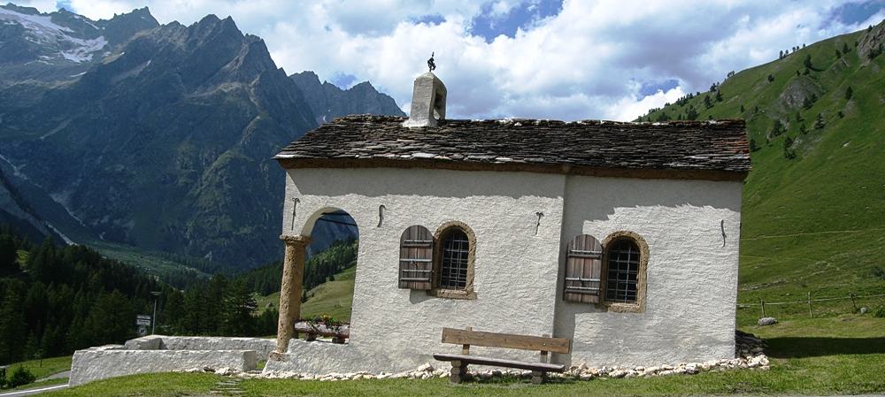
Ferret Chapel
The gentle descent to La Peule can be savoured as much as the vegetable soup (bouillon) served up at this summer farmstead – accompanied by a doorstop of freshly-baked bread. From here we err on the side of caution and opt for the less demanding, all-weather trail that takes us down to Les Ars and along the Swiss Val Ferret.
It takes around an hour to arrive in Ferret, a charming frontier village. The hamlet merits a visit before crossing the raging torrent that is La Drance de Ferret. Failure to do so means missing that picture-postcard chapel – a must irrespective of your faith. The sentier des Bergers is the final delight of the day before you enter La Fouly and enjoy an evening in your 3-star hotel.
The Spice of Life
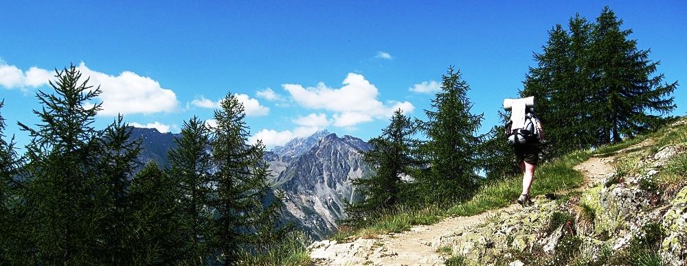
Day Three of this description of walking the TMBs northern half, from La Fouly to Champex, starts with a quick glance at the weather outlook posted at the Tourism Office. Pass the ramshackle internet café/chalet, cross the Torrent again and strike out northwards along the attractive banks of ‘La Drance’.
On this most gentle of stages, relatively-speaking of course, the day commences without the habitual climb – although do save a bit of energy for the early-afternoon ascent to Lac Champex. This takes you from 1055 to 1473 ms altitude along the Sentier de Champignons: an invitation to learn-as-you-hike, so to speak, rather than gather-as-you-go.
The walking is quite varied: an open ledge reminiscent of the Gorges du Tarn; an enclosed and tree-lined embankment; a pastoral stroll on a minor tarmacked path, with nothing to obscure the views of the fabulous mountain scenery including Le Catogne; and the human interest on offer between the villages of Praz de Fort and Issert. Consider lunching in the latter before enjoying several fine belvederes en route to ethereal Champex.
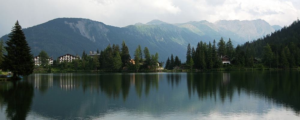
Little Canada
Champex encapsulates everything good about Switzerland – quality of life, organization, tranquility and welcoming: everyone you pass around the lakeside makes a point of saying ‘bonjour’.
The adjectives ‘picturesque’ and ‘quaint’ were most likely coined here. “Little Canada” may well be an apt label, but ‘Swiss country life in microcosm’ is another. Do arrive as early as you can in order to imbibe the good life and enjoy a lakeside saunter.
Nestled in the shadow of mont “La Breya” at 1500 metres altitude, Champex lies in Switzerland’s largest canton, Valais, reputed for its fine wines and cuisine. It has a long history of welcoming visitors to its peaceful lakeside hotels. The village is little more than a linear settlement stretched out along the eastern shores of the lake, but there is everything here you need.
The Climb to Bovine
Day Four of walking the TMBs northern half, Champex to Col du Forclaz, sees you bidding farewell to the mist-covered lake and heading north-west for some sixty minutes on a mix of tarmac and light stony trail. First stop is at the Auberge de Bon Abri and Plain de l’Au, where there is a small bar for drinks and snacks.
From here the main challenge of the day commences – a climb of 660 ms to the working dairy farm of Bovine [alt 1987 ms.] The ascent is in stages, so opportunities abound for taking breathers. Once above the tree-line, access to Bovine is via a fine ridge of gentle gradient.
Collet Portalo(u)
As you approach, the sub-alpine air is rich with bovine aromas and the sound of cow bells. Enjoy the splendid views down valley to Martigny and the sight of Grand Combin in the distance. The food is nutritious, too; especially the vegetable soup (bouillon), omelets and fondue. You may have to queue for access to the one available toilet before you continue on your way with a short climb up to a gateway at Collet Portalo(u) [alt 2050 ms].
Most Northerly Point
From here onwards to Col du Forclaz, a descent of 500 ms, it is inevitably nearly all downhill. The trail is rocky, tree-knurled, relatively-steep and tree-covered to start with, but gets gentler and more open as you progress.
The sound of traffic announces your arrival at the Col and its welcoming auberge and general store. Enjoy a drink on the popular roadside terrace and your last chance to purchase those priceless Swiss souvenirs. You have reached the most northerly point of the TMB trail and the furthest away from Mont Blanc itself.
Franco-Swiss Frontier
With your fifth day of walking the TMBs northern half, from Col du Forclaz to Argentiere, the challenge is ratcheted up a notch as you descend to the charming village of Trient with its prominent Romanesque church.
Then stride out on the tarmac to Le Peuty for 15 minutes before your boots grace earth once again. Cross a field of yellow gentians and arrive at and cross the raging Nant Noir ravine. This signals the commencement of a three-hundred-meter climb in the shade, but with no views to appease your panting lungs.
From approximately 1745 ms alt, the path becomes a little less steep and the open nature of the countryside is guaranteed to occupy the mind. From the base of a rock staircase, you get your first fine views back down the Trient Valley as well as a glimpse of the refuge de Col de Balme up ahead – the day’s highest point and lunch spot.
Sitting on the Franco-Swiss Frontier, this refuge boasts the TMB’s worst toilet, some of its most expensive canned drinks and begrudging service. There’s only bottled water available and the exposed terrace is seemingly designed to ensure hikers refrain from lingering for too long – not the best welcome to France!
Col de Balme
Despite the refuge, then, you can congratulate yourself for reaching the giddy heights of Col de Balme [alt 2191 ms] and arriving at the Swiss-French border. From here the views down along the Arve valley are quite stunning and you catch first sight of Mont Blanc’s snow-covered dome itself.
We follow the direction to the Col de Possettes and at the main junction [alt 1997 ms] opt for the lower, all-weather path (dir. Tre Le Champs). This passes above the Chalet de Balme [refreshments], avoiding the tricky Aiguillette des Possettes, especially in poor weather.
You have now done the day’s hard work and the rest of the trail is fairly easy-going. You traverse some delightful alpine countryside and enjoy views off left down to Le Tour on the river Arve.
A Pause at Tre-Le-Champs
When you eventually reach the main road connecting Argentiere to Col de Montets, you walk an embankment and then alongside the Arve river itself. The gite at Tre-Le-Champs has a welcoming garden terrace for drinks before you continue the gentle walk down into Argentiere and the comfort of your fine hotel in the main street of this busy little settlement.
The Choice is Yours
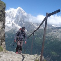
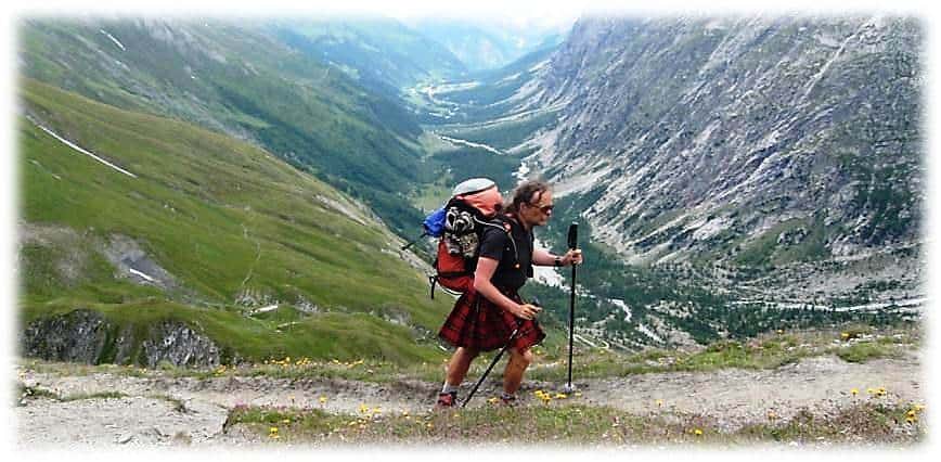
The final day of your walking the TMBs northern half experience provides a choice. Opt for the TMB proper or an approved variant between Argentiere and Les Praz de Chamonix according to personal tastes and the prevailing weather conditions. For those who suffer from vertigo, and if visibility is poor or rain predicted, take the red and yellow GRP from Col de Montets and hike the remarkable ‘Grand Balcon du Sud’ and the Massif des Aiguilles Rouges.
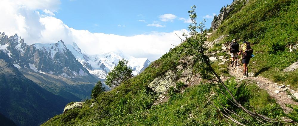
Alternatively, if metallic ladders pose you no problems [and they are quite modest and used by most] then opt for the main TMB route [GR]. The initial gradient is much gentler and the roaming ibex a main attraction on the way to the needle-like rock outcrop known as Les Aiguilettes – with its bird’s eye view of Argentiere 800 metres below.
The first section of ladders is quite steep, but they are very sturdy and the grab handles along the ledges excellent. These allow you to negotiate the challenge with minimum difficulty aided by platforms and timber steps. The photos below should help you decide whether the GR is the right option for you.

Lac Blanc
Whichever route you take on the final day of walking the TMBs northern half, you will enjoy the finest views there are along the entire western side of the Mont Blanc massif. You converge on Lac Blanc and its fine refuge for a memorable terrace or lakeside lunch.
Then enjoy a stroll round the tarn’s shores, space permitting! The stepped descent to La Flagere takes about 90 minutes from here and make sure you reach the cable car station by 17.45. If you don’t, you can add an extra hour to your day for the descent to the valley below and your celebratory meal – Chamonix itself can wait!
© The Enlightened Traveller 2021
Further Reading:
To enjoy walking the TMBs northern half, see:
To read about the more challenging southern half of the TMB, see:
And to walk the southern half of the TMB, see:
For the whole Tour du Mont Blanc, see:
For short, 4-night taster tours see:

![]()
Click to visit The French Hiker’s Guide to Holidaying in the Hexagon and France self-guided walking, trips, trails, places & themes.