Why walk the St-Guilhem Way? Le Chemin de St Guilhem takes you from the rolling highlands of Aubrac to the coastal lowlands of the Languedoc. You cover a distance of 112 miles in ten days and traverse four French departments: Aveyron, Lozère, Gard and Herault.
Several themes can be explored between the volcanic Aubrac Plateau and the undulating Mediterranean Garrigues: limestone table-tops and deeply-incised canyons; the Aigoual massif, southern Cevennes’ highest; and the geological miracle that is the Cirque de Navacelles. Not to mention the Grand Finalé of St Guilhem itself – a joy to behold!
Why walk the St-Guilhem Way? From Ste-Enimie to Navacelles you get to walk inside the Cévennes National Park. Created fifty years ago, it provides protection to the area’s rich fauna and flora. It is also the only national reserve in France to be inhabited by working farmers and artisans. This is the main justification for its UNESCO world heritage status.
Six BIG reasons to walk the St-Guilhem Way
1. Lozère
When tourism offices merge because one in each location is unjustifiable, you know you are successfully ‘getting away from it all.’ The nearby Nasbinals tourism office (on the Le Puy to Conques ‘Camino trail’) refers to its location as ‘the desert.’
Lozère has a population of 76,422 (2016), making it France’s least-populous department. This is a paltry 15 inhabitants per square kilometre. Lozère also boasts France’s highest average altitude at 979 metres, with all 185 of its communes classified as lying in « zone de montagne ». Both are excellent justifications to walk the St-Guilhem Way
Lozère was created in 1790 from the remnants of the ancient province of Gévaudan. There was a proposal to call it the ‘department of sources’ in recognition of its role as a departmental-wide ‘water tower’: it distributes H²O to the surrounding regions, whilst receiving none in return. With so many rivers within its confines, it is surprising they chose to name the department after Mont Lozère, its highest point at 1699 ms altitude.
No less than 437 rivers spring up within the territory, which feed three major drainage basins:
• Le Rhône, via the Chassezac and the Gardon rivers that so sculpt the Cévenol slopes;
• La Loire, via the Allier and its tributaries; and
• La Garonne, via the Lot, the Truyère and the Tarn.
2. Sheep migration in Cévennes
The herders have their permanent home in the latter and migrate in the summer to the former. It was very important to agriculturally-based societies, as the dairy products of transhumance flocks and herds (milk, butter, yogurt and cheese) formed much of the diet of such populations.
The principal of migration is so ancient that experts say it is anchored deep inside the animal’s psyche – a kind of ‘collective memory’. Herds appear to have an intuitive knowledge of the trail itself. They literally wake up at sunrise and spontaneously pick up the trail ahead, as if aided by genetic programming.

Sheep migration is a phenomenon that is endemic to Cévennes. Since the middle of the 19th century, the magnitude of the migrations has significantly declined. Mont Lozère, Cévennes’ highest peak, welcomed 100,000 sheep in 1703. This number had fallen to 21,000 in 1961 and 10,230 in 1977. In the decade 1970-1980, the Parque National received 30,000 sheep from around twenty herds. Today, strictly confined to the Mont Aigoual and Mont Lozère massifs, the numbers are around 20,000 sheep from roughly fifteen migrating herds.
Transhumance is commemorated via two local festivals. One around St Chely d’Aubrac at the end of May, while the more established one takes place at l’Espérou on a Saturday in the middle of June.
3. A Pilgrimage trail
William was subsequently defeated, but his obstinate resistance exhausted the Muslim forces, who retreated to Spain. In 801, William commanded a large expedition alongside the King of Aquitaine that liberated Barcelona.

In 804, William founded the abbey in Gellone (now Saint-Guilhem-le-Désert). Among his gifts to the abbey was a piece of the ‘True Cross’. This had been gifted to him by Charlemagne, who had received the relic from the Patriarch of Jerusalem. In 806, William retired to Gellone as a monk, where he died on 28 May 812. His reputation grew posthumously and he was canonized a saint in 1066 by Pope Alexander II.
The first tourists were the pilgrims, and there were several ways to get from Le Puy-en-Velay to Rome or to Santiago de Compostela. The Via Podiensis was and remains the most important French Camino. However, two alternatives served those travellers with time to spare and explore Cevennes and the Lower Languedoc: Chemin de St-Gilles in north-eastern Cevennes (aka The Regordane, medieval Christendom’s fourth-most-important pilgrimage trail) and The St-Guilhem Way in the south. Both allowed for visits to sacred sites (the Abbey of St Gilles and Gellone, respectively) before the pilgrim opted to head east to Rome or west to Compostela via the Arles Route. So you are in good company when opting to walk the St-Guilhem Way
4. An important historical trading route
The uncertainties of the 15th century (epidemics, Hundred Years War, marauding bands of highwaymen) slowed down the flow of trade, as too did the Religious wars of the 16th and 17th centuries. The Camin Romieu was still frequented by merchants until the end of the 17th century. Thereafter it was abandoned in favour of new, ‘Royal Routes’ – roads made suitable for vehicles by the Sun King’s administration during the Protestant uprising in Cevennes and Lower Languedoc (1685-1710).
Whilst chestnuts were the staff of life in Cévennes, silk was an important industry. The spinning of silk yarns had been the main economic activity in many Cévennes villages since the Middle Ages. It flourished in the 16th century under the reign of Henri IV, who encouraged its production to compete with expensive imports from Italy.
Evidence of this past activity can still be observed in the architecture of some houses, many of which were re-designed and raised in height in order to create upstairs silkworm nurseries. In the 18th century, silk production grew further, with silk stockings made in Aulas or Le Vigan exported throughout Europe and even to the West Indies.
From its small-scale, home-based production origins, silk production became a mechanised and factory-based industry. It reached its peak around the 1840s, employing many women and girls in local silk spinning mills. Decline set in during the second half of the 19th century as a result of silkworm disease and intense competition from Asian imports. Silk substitutes marked the end of the silk industry in the 20th century; although there is still one workshop at Monoblet where silkworms are bred and silk materials created using innovative methods.
The building that houses the museum of Cevenol life in Le Vigan, located on the banks of the river L’Arre, was once a silk spinning mill. The spinning mill in Aulas, built in the middle of the 19th century, was used to spin cotton. This activity stopped around 1975.
5. Rich in human heritage
Burons were used to make cheese in the summer, but often had an area for sheltering sick calves or cows. They are located near springs, the production of cheeses requiring a lot of water. Cheese was made in the burons until the Second World War, since when these little houses have been gradually deserted.
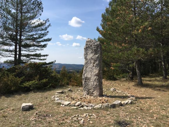
When you walk the St-Guilhem Way you discover Prehistoric heritage in the form of megaliths – dolmen, menhir and cromlech. Megaliths are large and roughly hewn stones erected from the end of the Neolithic Period. They had a religious function, were used as graves/ grave stones or to commemorate an important event.
There are calculated to be nearly one thousand megalithic tombs or dolmens on the Grands Causses. They were used and reused for centuries, some dolmens serving as shelters to store tools or simply as shelters from inclement weather.
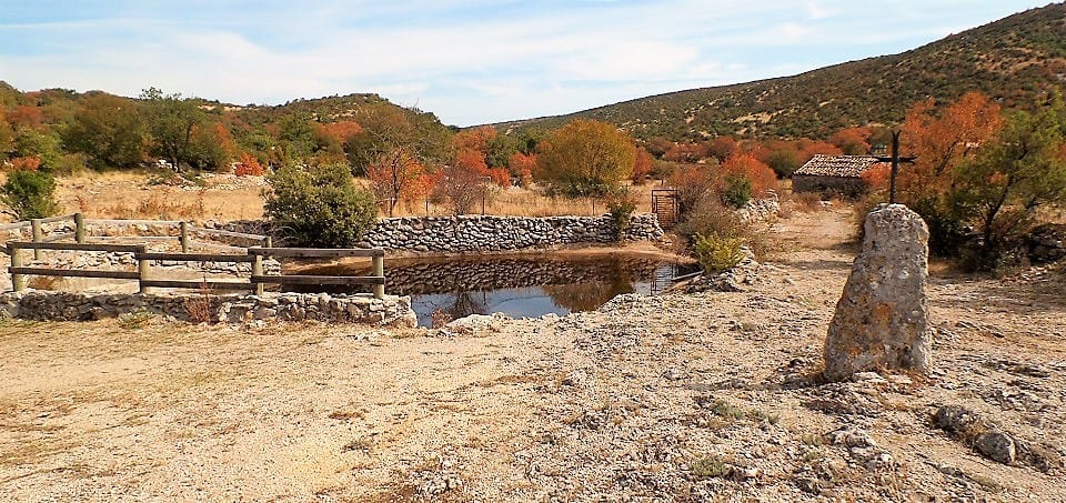
A menhir is an isolated and often huge monolith. Its meaning is still unknown and there are several to be enjoyed en route. With the advent of Christianisation, many of these sacred stones were toppled. Others were christianised with a cross placed on top, such as the one you will visit on the Causse de Blandas near the hamlet of Les Lavagnes.
After the region of Brittany, Causses and Cévennes is the French ‘region’ where megaliths are at their most numerous. From north to south along the Trail, and commencing with the Causse de Sauveterre, one can see the dolmen of La Rouvière, the dolmen of La Cham and the Aire des Trois Seigneurs. To the north of Sainte-Enimie, the menhir of Le Bac can be admired. Having traversed Cévennes, the Causse de Blandas boasts 70 menhirs, dolmens and cromlechs.
One cross stands out from all the others along the way to Saint Guilhem – La Croix de La Rode in the Aubrac region. La Rode is so called because of its shape: “rode” meaning “wheel”.
The “lavognes” are small, circular and natural hollows in the ground found on the Causses. In these dry regions, man has nurtured them in order to hold rainwater. The earth is covered with clay, or paved with limestone, so that the water does not seep into the soil. The water level varies with the seasons; and whilst these ponds are used principally for watering cattle, they support a diverse ecosystem of amphibians and dragonflies.
6. UNESCO World Heritage
Walk the St-Guilhem Way and you traverse land almost entirely inscribed within UNESCO’s world heritage under the rubric of Mediterranean aggro-pastoralism.
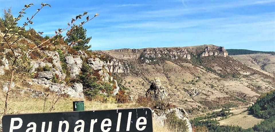
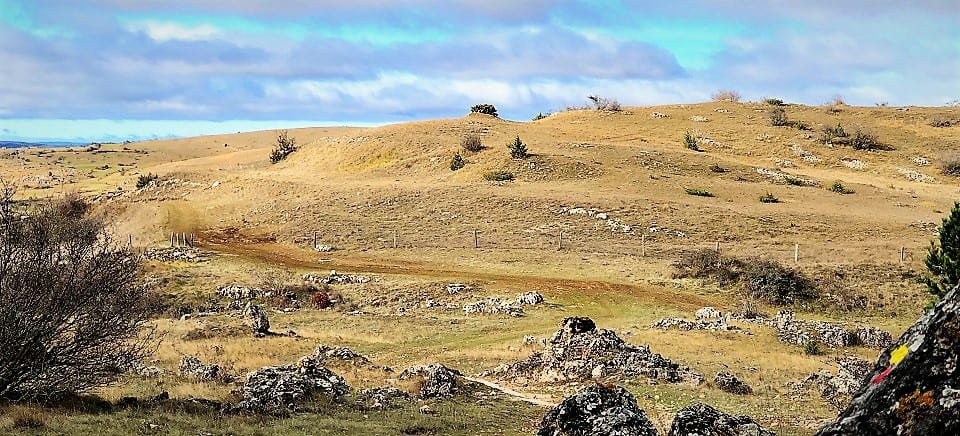
South of the Aubrac region, the Grands Causses are undulating limestone plateaux or table-tops with a remarkable flora. You will walk on four of these Causses on the way to Saint Guilhem. Firstly, en route to Ste-Enimie, the Causse de Sauveterre; between Ste-Enimie and Meyrueis, the Causse Méjean; the Causse de Blandas after Vigan and the Causse du Larzac after Navacelles on the penultimate day.
The Causses are separated from each other by valleys and deeply-incised gorges or canyons. You will cross the Gorges du Tarn at Ste-Enimie and the Gorges de la Jonte en route to Meyrueis – the only inhabited canyons in France; while the Gorge de La Vis marks the limit between the Causse de Blandas and the Causse du Larzac.
The Caussenard economy is based on sheep rearing. Animals are reared for meat, but also for milk used to make local cheeses, like the Bleu des Causses. Man has shaped the landscape: dry stone walls along the roads act as limits between land parcels; clapas (heaps of stones that have been removed from a field that will be cultivated); and dolines, small depressions with a fertile, clay bottom, where grain and forage can grow.
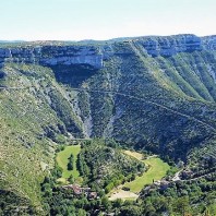
The Cirque de Navacelles, a UNESCO treasure and Grand Site de France, is admired from above by hundreds of thousands of tourists every year. This alone is reason enough to walk the St-Guilhem Way. However, few get to experience it the way you will when you walk the St-Guilhem Way. Three hundred metres deep, the Cirque is a former oxbow lake or dried-up river meander.
La Cirque was created as the river Vis forged a more direct route through the landscape, creating an eight-metre high waterfall in the process. At its centre lies the « Rocher de la Vierge », more commonly known as the « oyster. » It is surrounded by a strip of very fertile land – the old river-bed or meander. Its green fields, the waterfall and the woodland contrast markedly with the steep, dry and rocky sides of the canyon.
At the top of Mont Aigoual is the Aigoual Observatory, the only mountain-based meteorological station still active in France. The Observatory, built at the end of the 19th century, is a landmark in Cévennes.

Why walk the St-Guilhem Way? In essence, The Saint Guilhem is quite simply a great learning experience as well as a fine hiking trail. So what are you waiting for? Booked your place and look forward to an extremely enlightening trip.
© The Enlightened Traveller 2020 – Not to be re-produced or copied. All rights reserved.
Further Reading:
To walk the St-Guilhem Way, please see:
To watch a video of the St-Guilhem Way, please see:
Click to visit our BLOG page, The French Hiker’s Guide to Holidaying in the Hexagon and France self-guided walks, trails, trips, places & themes.